Basin Water Organization “Syr Darya”
Basin Water Organization “Syr Darya” is an executive and inter-ministerial body of ICWC which is responsible for water delivery within the agreed water withdrawal limits in the Syr Darya River Basin.
![]()
Briefly about the basin
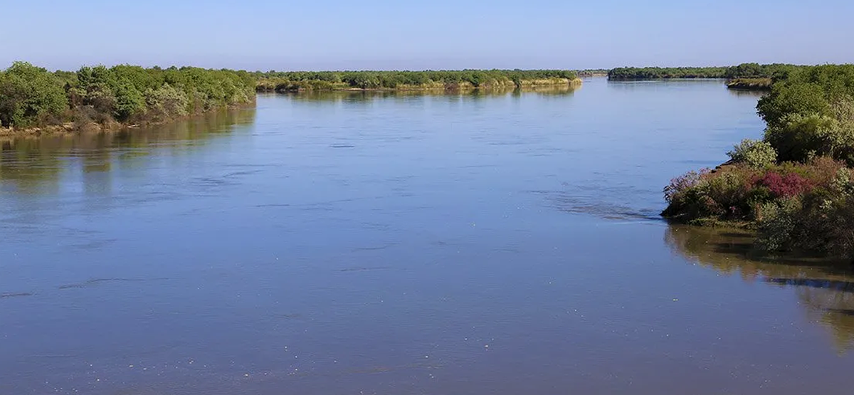
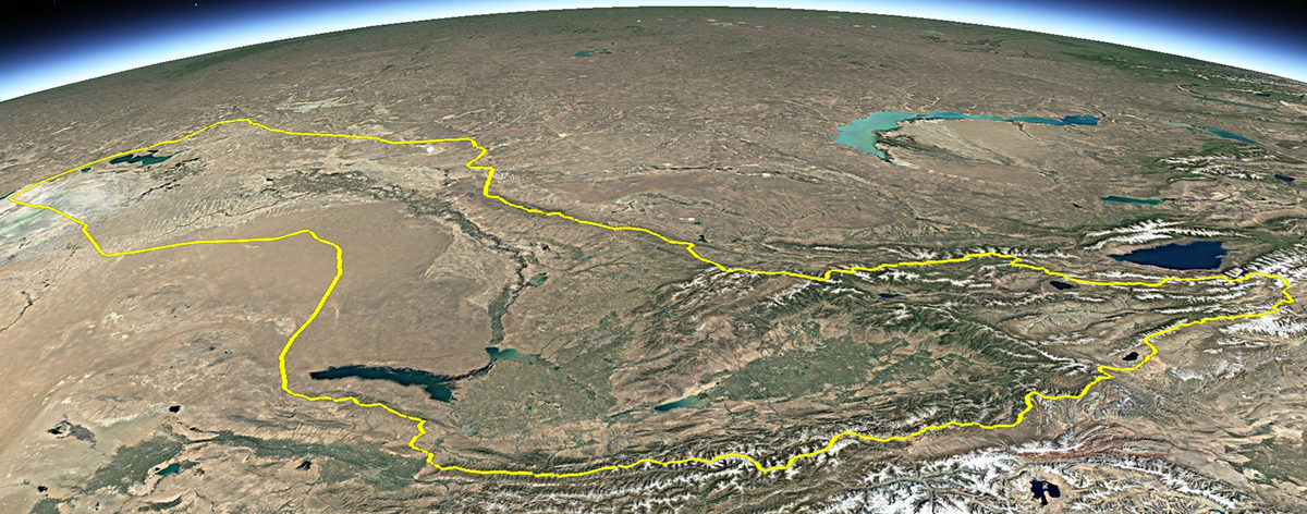
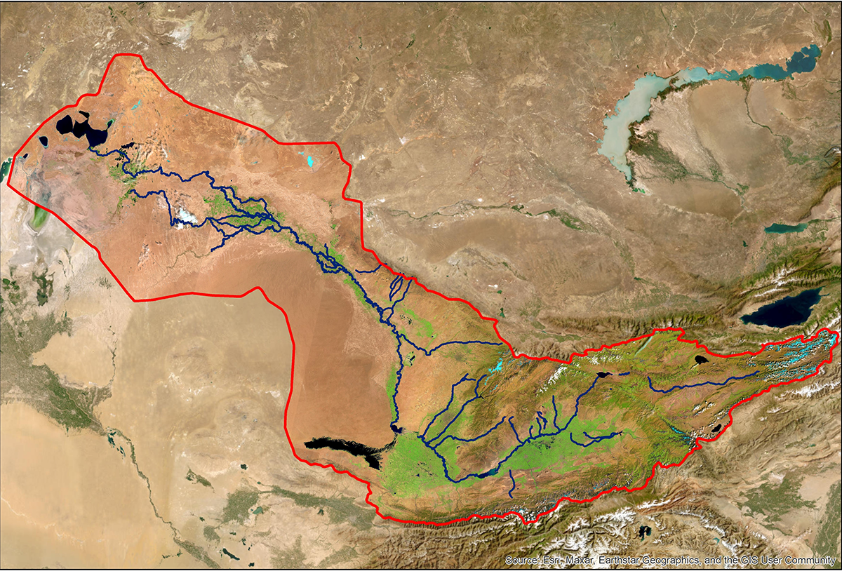
Syr Darya river basin comprises the following Central Asian sovereign states: the Republic of Kazakhstan, the Kyrgyz Republic, the Republic of Tajikistan and the Republic of Uzbekistan. The length of Syr Darya from the confluence of Naryn and Karadarya rivers to the Aral Sea is 2337 km, and with Naryn river — 2790 km, basin area is 150 100 km2.

Average annual Syr Darya basin flows for the last years are 40.8 km3. Owing to unique Syr Darya water system it is feasible also to use 6.7 km3 of return waters. There are five water reservoirs on Syr Darya and its tributaries:
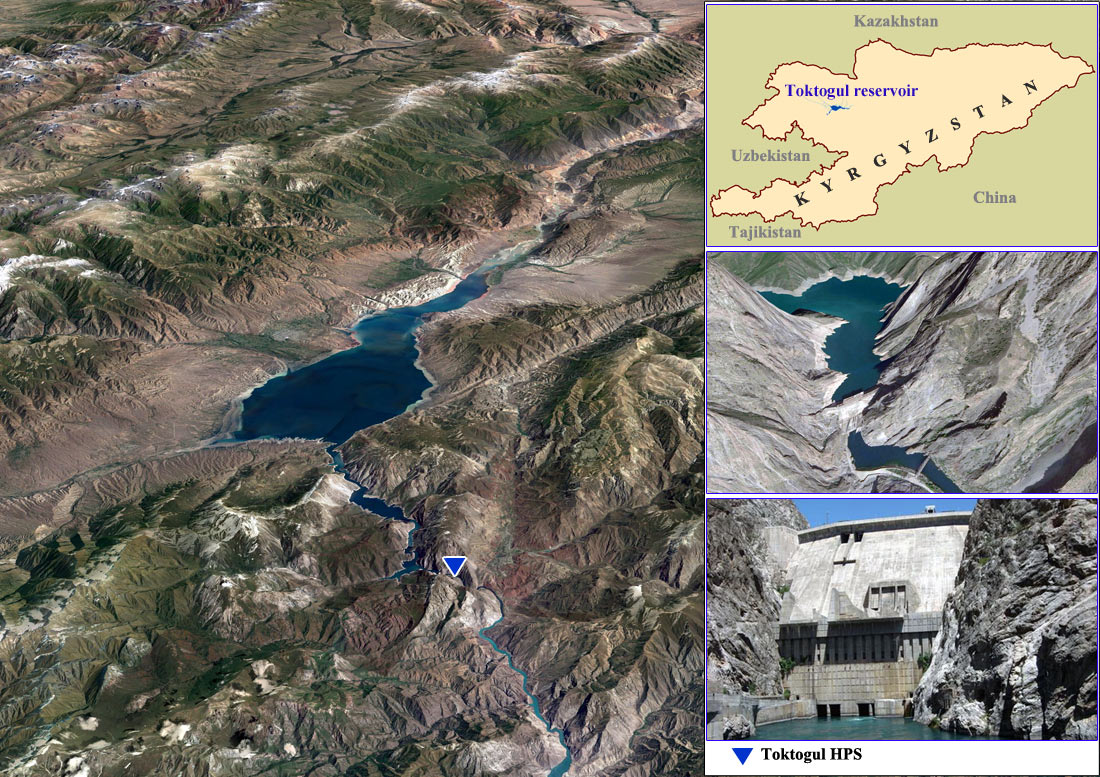
• Toktogul reservoir: total capacity is 19.5 km3, including effective capacity of 14 km3.
• Andijan reservoir: total capacity is 1.9 km3, including effective capacity of 1.75 km3.
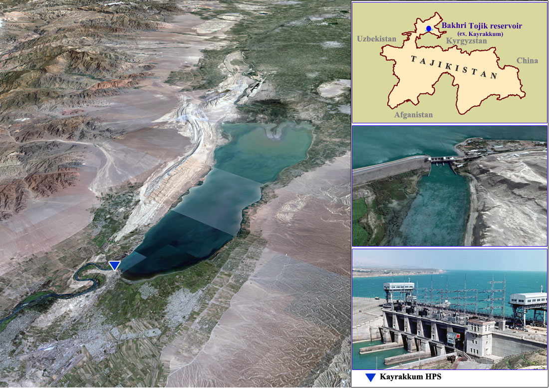
• Bakhri Tojik (ex Kayrakkum) reservoir: total capacity is 4.03 km3, including effective capacity of 2.55 km3.
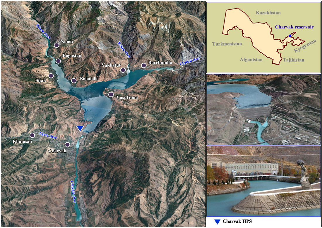
• Charvak reservoir: total capacity is 2.05 km3, including effective capacity of 1.6 km3.
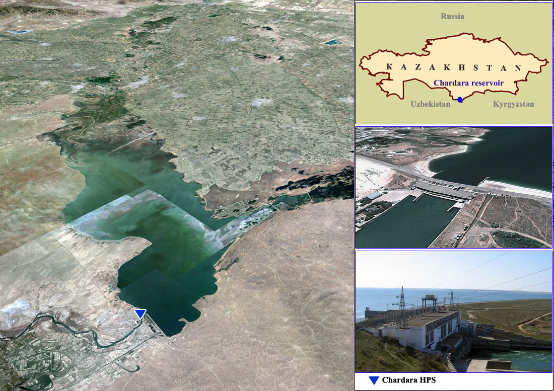
• Chardara reservoir: total capacity 5.4 km3, including effective capacity of 4.4 km3.
Toktogul reservoir and HPS
Charvak reservoir and HPS
Andijan reservoir and HPS

Chardara reservoir and HPS
Bakhri Tojik reservoir and Kayrakkum HPS
Naryn and Syr Darya river water consumption of the states as a whole in the last years is average 25,27 km3 a year allowing for limits, including water supply to the Aral Sea and in-channel losses downstream Chardara reservoir on the territory of Kazakhstan.
n the present context, water withdrawals directly from the Syr Darya River by the Central Asian republics are as follows (in percentage):
• Republic of Kazakhstan – 41.5 % (including water supply to the Aral Sea);
• Kyrgyz Republic – 0.82 %;
• Republic of Tajikistan – 7.44 %;
• Republic of Uzbekistan – 50.24 %
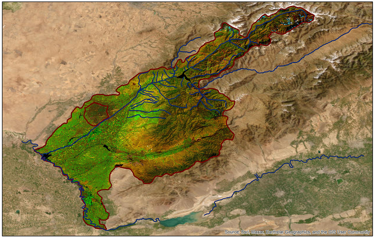
Syr Darya river basin map based on satellite images
Karadarya river basin map based on satellite images
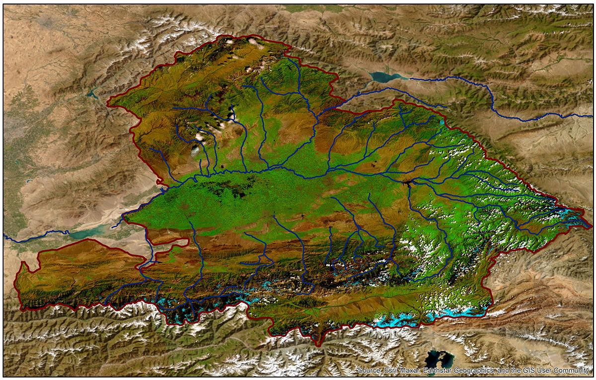
Chirchik river basin map based on satellite images
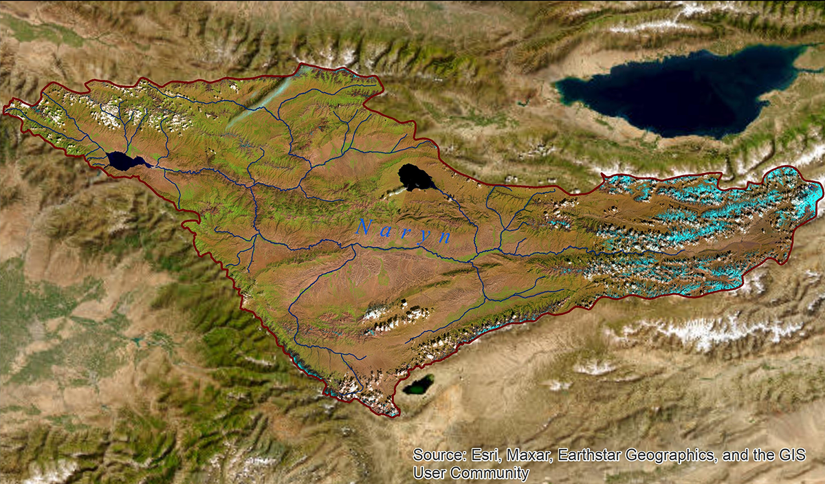
Naryn river basin map based on satellite images
Background
After consecutive low water years, in 1980 the Aral Sea basin states faced to serious problems in water resources management. To solve conflict situations and to improve water allocation among the states in a context of an extreme water shortage, the Ministry of Reclamation and Water Resources of the former USSR formed two basin water organizations — BWO “Amudarya” and BWO “Syr Darya”. The presence of skilled specialists and a direct relation with the Ministries of Water Resources of the republics allowed to improve water resources management, to introduce order in water allocation, taken water volumes limitation and water accounting for a short time.
After the collapse of the USSR, to ensure effective water resources management, the Ministries of Water Resources of the five Central Asian states approved “Agreement between the Republic of Kazakhstan, the Kyrgyz Republic, the Republic of Tajikistan, Turkmenistan and the Republic of Uzbekistan on Cooperation in the Field of Joint Management on Utilization and Protection of Water Resources from Interstate Sources” in respect to the Aral Sea basin as a result of a series of negotiations, meetings and discussions. Interstate Coordination Water Commission (ICWC) with its executive bodies — BWO “Amudarya” and BWO “Syr Darya” — was established. This Agreement, signed in Almaty on 18 February 1992, and other documents and acts, accepted by Central Asian states in the last years, are the basis for interstate water resources management.
Water resources management
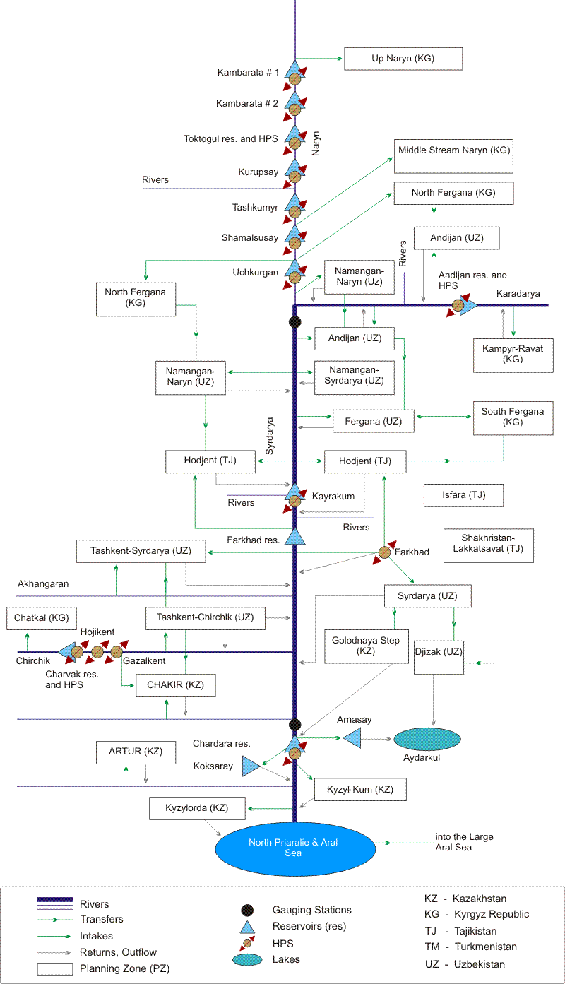
BWO Syr Darya is responsible for transboundary water management and interstate water allocation from the Toktogul reservoir to the border of the Republic of Kazakhstan (the Shardara reservoir).
BWO Syr Darya:
• drafts and implements decisions of the Interstate Commission for Water Coordination (ICWC) regarding water resources management;
• operates hydroschemes and intake structures;
• distributes water resources and transports them along the main canals;
• takes measures for environmental improvement and water quality monitoring;
• monitors (together with national Hydromet services in Central Asia) the flow regime of the Naryn, Karadarya, Chirchik, and Syr Darya rivers from the Uchkurgan HPS and Andizhan HPS to the Shardara reservoir;
• performs real-time operations control of water and water-energy resources (together with CDC “Energy”) in the Syr Darya Basin;
• performs real-time control over of observance of water withdrawal limits.
The organization has headworks on Syr Darya river and its main tributaries: Uchkurgan waterwork with a capacity of 3000 m3/sec on Naryn river, Kuyganyar waterwork with a capacity of 1400 m3/sec on Karadarya river, Verkhnechirchikskiy waterwork with a capacity of 1800 m3/sec on Chirchik river, etc., and also canals of interstate significance (first of all, “Dustlik” canal and Big Fergana canal head). BWO has at its command 198 hydraulic structures, 21 of which are located on the main channels of Naryn, Syrdaya, Karadarya and Chirchik rivers. The capacity of the structures is between 20 and 3000 m3/sec, and the discharges of the structures on “Dustlik”, Big Fergana and South Golodnostepskiy canals reach 350 m3/sec.
he main water consumer in the Syr Darya region is irrigated agriculture, which occupies an area of 3.38 Mha. The irrigated land on 1.73 Mha receives water directly from the river. Besides, water is delivered for industrial, utility, environmental, and ecological purposes and to the Aral Sea. Accounting of water intake from the rivers and subordinated canals is done at 445 points, including 21 head intakes, З6 stationary pumping stations, and 172 temporal pumping units. Surface water accounting is undertaken mainly by Hydromet services directly along the rivers and by the BWO Syr Darya and water organizations of the neighboring countries at water intake structures.
The water system governed by BWO Syr Darya is operated mainly for transportation of normal, guaranteed flow and also under extreme conditions, i.e. in case of extraordinary low-water and for trouble-free routing of high flood in extremely high-water years.
To ensure this, the BWO takes into account river flow, water use plans (limits), and water storage in reservoirs in given period of time.
Given the multiyear flow regulation, according to the Naryn-Syr Darya cascade project, reservoirs are drawn down during a series of years, depending on availability of water resources, needs for water and probable changes in operation regimes of the Naryn-Syr Darya water tract. Therefore, in such cases, control of water resources is performed by year to maintain the guaranteed operation regime of the reservoir cascade. Rare floods are carried along the Syr Darya River through 'cutting' of flood peaks by surcharge storage, which equals 0.8 kmЗ per the Toktogul, Bakhri Tojik, and Shardara reservoirs. First, non-regulated flow of the Karadarya River, Fergana Valley's rivers and induced water releases from the Toktogul reservoir are handled. The project was designed in such a way that the Toktogul reservoir was to ensure compensatory regulation, i.e. make additional releases of water in case of its shortage in the Syr Darya main stream for irrigation purposes during low-water periods. The compensatory regulation proceeds from carrying capacities of river hydroschemes and the river channel itself in different reaches. The Bakhri Tojik reservoir transforms flood and balances its water releases, based on channel capacity of the Syr Darya. The Shardara reservoir regulates water releases from the Bakhri Tojik reservoir and flood flows of the Syr Darya's tributaries at the reach Bakhri Tojik – Shardara. Such system guarantees safe and failure-free operation of rivers' hydroschemes, intake structures, and main canals.
Based on river water availability forecasts for the non-growing and growing seasons and the water storage in the reservoirs of the Naryn-Syr Darya cascade, BWO Syr Darya prepares the operation regime of the reservoir cascade and the limits of republican water withdrawals and submits them for approval by the ICWC. The approved limits present the basis for implementation of the interstate water allocation through canals and pumping stations. Those limits of water withdrawal may be corrected depending on the actual water-related situation. If the correction exceeds 10 % of the total amount, the limits are revised at ICWC meetings.
The approved limits of water withdrawal for republics, canals, and pumping stations, with decade-wise division in each month, are brought for fulfillment by territorial divisions of BWO Syr Darya. Water accounting along the Naryn, Syr Darya, Karadarya, Chirchik rivers, as well as small rivers is performed through control gauging stations by republican Hydromet Services. As to the main canals that divert the river water, water accounting is kept through head hydroposts served by BWO Syr Darya, including the main Dustlik Canal and the BFC. Operational water management is performed by the BWO from the master station that is connected with territorial divisions and hydroscheme administrations.
The regular monitoring of surface water in the Syr Darya basin is provided by river gauging stations under responsibility of the republican Hydromet services in Central Asia and by hydroposts of BWO Syr Darya at intake structures.
Downstream of the Shardara reservoir, similar work is undertaken by the BWO “Aral – Syr Darya” at the Committee of Water Resources of the Kazakh Ministry of Water Resources and Irrigation.
Syr Darya's linear scheme: probable scenario and risks
Structure of BWO Syr Darya
The institutional structure of BWO Syr Darya is comprised of three levels: central office in the city of Tashkent, territorial divisions, and local control and monitoring units.
The BWO's central office governs the overall work through the territorial divisions, based on the operation regime of the Naryn-Syr Darya cascade of reservoirs and the water withdrawal limits established by the ICWC for the non-growing and growing seasons of each hydroeconomic year. The territorial divisions regulate water supply in line with plans at the canals' headwork structures.
The central office prepares information on water availability and calculates water needs, plans water distribution among the four states and water supply to the Aral Sea and Prearalie, with account of each intake from the Syr Darya and the interstate canals, plans operation of the Naryn-Syr Darya cascade, and collects information on river water quality. Operational water management is performed through the master station of the BWO, which is connected with territorial divisions and hydroschemes.
BWO Syr Darya includes the following territorial divisions:
• Naryn-Karadarya hydroscheme and canal administration in Kuyganyar;
• Gulistan administration for hydroschemes and the Dustlik Canal in Gulistan;
• Upper Chirchik hydroscheme administration in Chirchik;
• Charvak reservoir administration in Charvak.
The territorial divisions control structures, monitor observance of water withdrawal limits, operate and maintain water infrastructure, and also monitor river water quality and how the environmental demands are met. The territorial divisions are responsible for water resources management in the reaches of the Syr Darya River and its tributaries, such as the Naryn, Karadarya, and Chirchik.
The third level of institutional structure is represented by the control and monitoring units that include head intake structures, dams, pumping stations, and hydroposts.
The Naryn-Karadarya Division has 4 operational sub-divisions and covers the system of the Naryn River basin from the Uchkurgan HPS to the confluence with the Syr Darya River, the Karadarya River basin from the Andizhan reservoir to the confluence with the Syr Darya River, and the Syr Darya River basin from the confluence of the Naryn and Karadarya rivers to the Akjar hydropost.

The Gulistan Division consists of 6 sub-divisions and is responsible for the system in the reach of the Syr Darya River from the Akjar hydropost to the Shardara reservoir, as well as for the Dustlik Canal and the head reach of the South Golodnostepskiy Canal. Besides, this Division controls distribution of water resources among Uzbekistan, Kyrgyzstan and Tajikistan along the Isfara River.
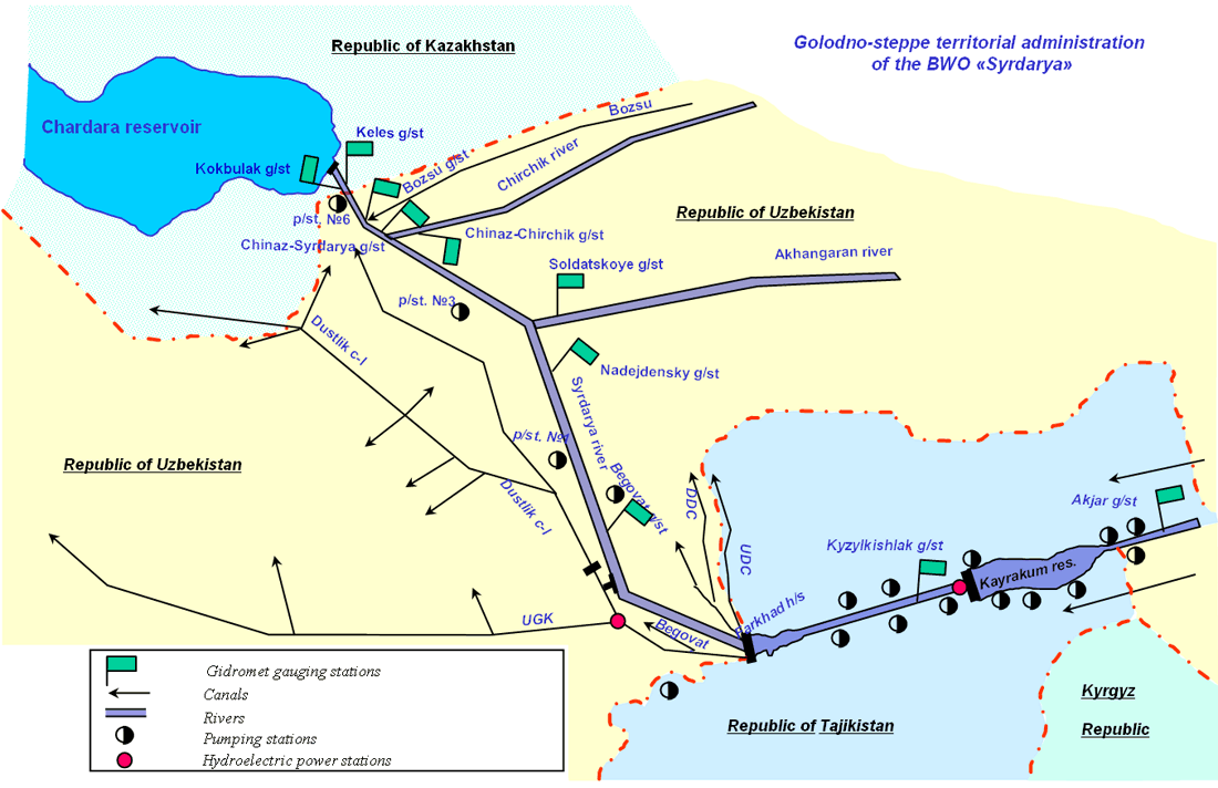
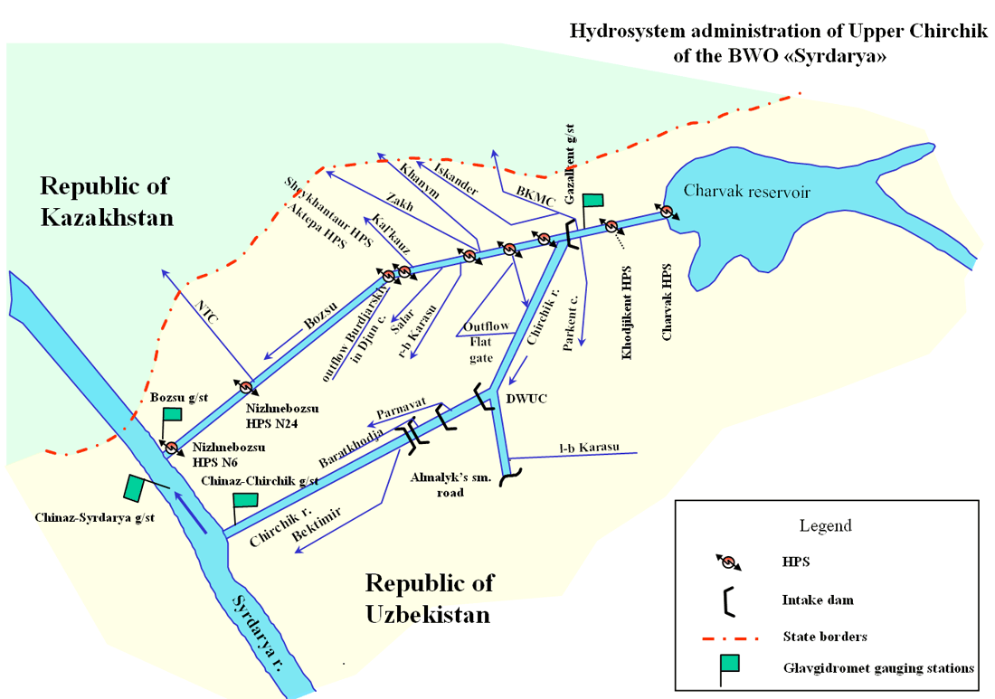
The Upper Chirchik Division has 3 hydrosites, distributes water between Uzbekistan and Kazakhstan, and controls the reach of the Chirchik River from the Charvak reservoir to the confluence with the Syr Darya River and the Bozsu diversion canal.
The Charvak reservoir administration includes 4 reference stations and is responsible for control of water quality, protection of water resources and the reservoir area with adjacent water-protection zone from pollution, and maintenance of good sanitary conditions.